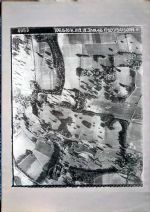
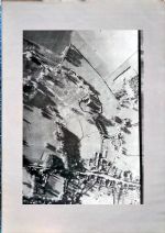
OS map Bridge and Patrixbourne parishes, post-1977; Surface features revealed by air photography to fit post-1977 map; NMR aerial photograph copy, Jan 1946, 400% part frame enlargement, Bridge Place area; NMR aerial photograph copy, 145% whole frame enlargement, Bridge Hill, Bourne Park, Bridge Place area, Jan 1946
Location
Maurice Raraty
Category
F - Folders / Individual items
Access
Public
This item is a raw import from the 2016 catalogue.